Topography and Agro-Climatic Characteristics

According to the Planning Commission Classification, the State as demarcated now falls in middle-Gangetic Plains region. ICAR's agro-ecological division puts it under the sub-humid ecosystem. Based on more desagregated classification, the state is divided into three agro-climatic sub-zones. These are north-west Gangetic plains (Zone I), north-east Gangetic Plains (Zone II) and the South-Bihar Plains (Zone-III).


Bihar is spread over 9.40 million ha of land. The three zones mentioned above constitute about 35, 21 and 44 per cent of total geographical area of the state respectively. Bihar, on the whole, is endowed with congenial climatic conditions for cultivation of wide range of crops and trees.


The three zones have little variation in climate having hot summer, wet monsoon and dry winter with temperature reaching above 45ºC in June. The minimum temperature reaches below 5ºC in January.


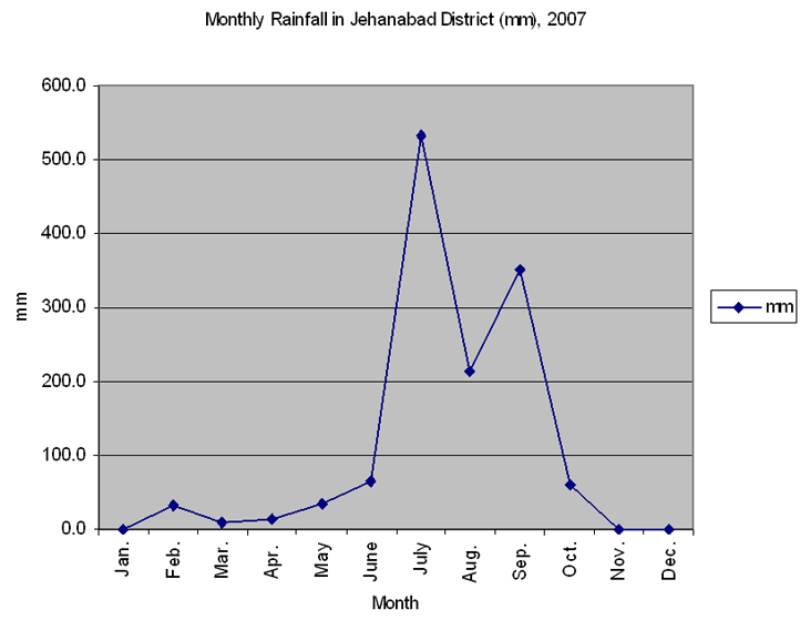
Jehanabad district fall in agro-climatic Sub-Zone III. The average annual rainfall in the Jehanabad district is 1313 mm (Fig. 1). This is just sufficient for the type of agriculture practiced traditionally in this district. But year to year variation make short fall from normal very common. In fact, the variability of rainfall leading to difficulty of agriculture during monsoon season is very frequent in the drier zone of the district. In addition, it must be remembered that the time to rainfall is also important. The timely rainfall is very crucial for the type of agriculture being practised in the district and it gives a boost to increase the production.


The rivers that flow through the district are Dardha, Phalgu, Jamuna, Morhar and Punpun. Most of these rivers remain dry for the major part of the year. But following the incidence of rainfall in their catchment basins the rivers swell up into rushing torrents and discharge the rainwater very quickly within hours through their slopingbeds.


The natural system of drainage of the district is characterised by two oddities against human settlements. First, quick loss of rain water creating difficulties in cultivation, and second, recurrence of sudden floods. Yet the settlement was made possible by the use of the same drainage characteristics in an indigenous way. Firstly, the soil characteristics and the gradient of the district has been utilised to create drainage tanks (ahars) in strategic positions which collect much of the drainage water in the plains and reserve those for future use in agriculture second, the rivers and rivulets are breached in strategic positions and the water is led into artificial canal (pynes), to agricultural fields and storage tanks and used for irrigation. This sytem of irigation is still very important in the district.


The soil in the district is old alluvian, sandy loam to clayey, slightly alkaline in patches. The soil correction is thus important for increasing agricultural production in the district. The soil nutrient status of the district is moderate and having an average range of nitrogen and phosphorous.


District Profile- Jehanabad   ATMA Jehanabad

Introduction of Jehanabad

Land Holdings Portrayal of the vision Introduction of ATMA Member of Governing board
Demographic profile Irrigation & Ground surface... Land use pattern Organization structure Member of AATMA Management
Literacy Yield gap Vision statement Hierarchical structure ATMA Cafetaria
Work participation rate District income     ATMA governing Board All events
Topography & Agro climate Preamble     ATMA Management...    
                   
Copyright © 2011 ATMA JehanabadAll rights reserved. Site Design & Maintenance : SAM Softech